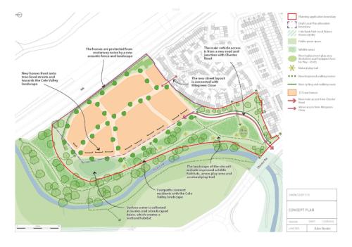
This is a project to provide new homes on the site of the former Simon Digby school. This 4.57ha site is located in Chelmsley Wood between the A452 Chester Road and the M6, to the east of the River Cole.

Located between the Chester Road (A452) and the M6 in Chelmsley Wood, the former Simon Digby school site was allocated for housing development in the adopted 2013 Solihull Local Plan. The 4.5 ha plot has the potential to provide up to 177 new high-quality sustainable family homes.
An indicative proposal for the site shows how it could be developed to include a range of much needed family homes fronting onto tree-lined streets, set amongst a pleasant natural environment with cycle lane provision and footpaths connecting residents to the Cole Valley landscape.
Central to the development will be a focus on creating a distinct sense of place. This is an exciting chance to create a thriving well integrated new community, perfectly positioned to benefit from the economic opportunities associated with the arrival of the HS2 interchange and the rest of the UK Central Hub. A significant proportion of the development will be made up of affordable homes in line with local planning policy.
Following the initial feasibility and technical surveys undertaken by Solihull Council, Vistry Group PLC has been appointed as the scheme developer.
Initial feasibility work, concept masterplan development and acquisition of land interests has been managed as part of the WMCA funded UK Central Infrastructure Programme. It is one of over twenty projects building upon the investment and regeneration planned for the borough, supporting further sustainable and inclusive growth.
Keep up to date with this project by signing up to our ‘Simon Digby Housing Development’ Stay Connected Bulletin.
What is the Simon Digby Housing Development?
Why is the former school site being developed?
The former Simon Digby school site is allocated as a site for new homes in the Solihull Local Plan that was adopted in December 2013. The Local Plan is the key planning policy document that establishes, amongst other matters, the scale and distribution of homes that are required to support the Borough’s needs. With an estimated capacity of 200 homes, the Simon Digby site makes an important contribution to the delivery of new homes in the borough.
How was the Solihull Local Plan decided?
The 2013 Local Plan was adopted following extensive public consultation, which took place between 2008 and 2012. This included consultation on the sites to be included in the Plan. Importantly, the Plan was subject to examination by an independent Planning Inspector before the Council was allowed to adopt it. Paragraphs 70-73 of the Inspector’s report contain his conclusions on the North Solihull sites that were included in the Plan, including the former school site.
What is planned?
Vistry Group have now submitted their planning application for the delivery of 177 new homes on the Simon Digby site. To view the plans in full and submit any comments visit https://publicaccess.solihull.gov.uk/online-applications/ and search for the following application: PL/2024/02981/PPFL
When is construction likely to start?
Construction cannot begin until planning permission has been secured.
What about flooding from the River Cole?
None of the housing will be within the flood plain. Information relating to the flood plain and likelihood of significant flooding events has been provided by the Environment Agency. A Surface Water Drainage Strategy will be developed and mechanisms to sustainably manage water onsite, such as swales, will be incorporated into the final design.
What will the impact be on open space?
Only around one third of the site between the A452, the M6 and the existing housing estate is designated for new homes. The rest of the area, which will be largely unaffected by the development, is predominantly woodland and river valley. The housing site does not include any of the Local Nature Reserve or Local Wildlife Site. Ecological surveys have already been undertaken and will be fully assessed as part of the planning application process.
What is the West Midlands Combined Authority (WMCA) funding used for?
The funding is being used to assemble the site, develop the scheme and will help provide the infrastructure that is needed to deliver the new homes, such as a new access road into the site.
Will there be affordable housing?
Solihull Local Plan sets out the requirements for at least 40% affordable housing in Policy P4A for qualifying sites. This will be considered in detail as part of the planning application process.
Will it be an environmentally sustainable development?
Reducing carbon emissions is a priority for Solihull Council. We recently adopted our Net Zero Action Plan which looks at the actions we will all need to take to reduce carbon emissions across the borough to net zero by 2041. It is intended that the development will be highly sustainable and incorporate cycle lanes, low carbon technology and electric vehicle charging.
Will there be a play area?
There is currently a play area on the site, adjacent to the Chester Road. This will be replaced with a new dedicated play area and nature trail as part of the project.
How is the impact on the neighbouring roads being considered?
It is proposed that access to the site will be facilitated with a new road to connect directly with the A452, in line with the Solihull Local Plan. There will be no significant increase in traffic expected within the existing neighbouring housing estate. Studies undertaken by the Council confirm that the proposed access road is deliverable. A pedestrian and cycle access to the site is proposed to link with Kitegreen Close.
How can I find out how the project is going?
We want to keep local residents up to date as this scheme is brought forward. If you would like to receive project updates, including notifications about any future planning applications, you can sign up to our ‘Simon Digby Housing Development’ Stay Connected email bulletin to receive project updates, including notifications about any future planning applications.
